
Umpiem Mai
Location
Khirirat Sub-district, Phop Phra District, Tak Province
Distance from Mae Sot
87 km, approx. 1½ hours driving time
Accessibility
Car: Good, all-year-round access from sealed road (public transport available)
Phone: Good mobile phone coverage in most parts of the camp
Internet: Privately-run internet services available in camp
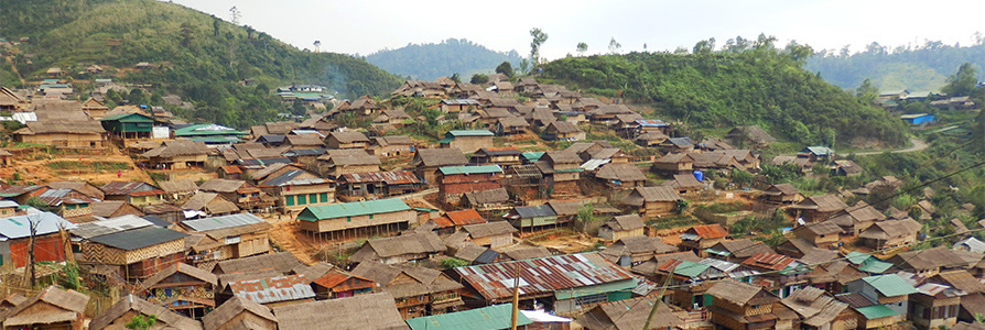
Camp Geography
Area 493 rai (79 ha)
Introduction and History
Umpiem Mai camp has a population of more than 10,600 people, of whom around 80 percent are Karen/Kayin, some 9 percent are Burman, and 3 percent are ethnic Mon.
Around 66 percent of the population come from Karen/Kayin State, some 12 percent are from the Bago Region in Burma/Myanmar, and around 11 percent are from Mon State. Small numbers also come from Rakhine State, Yangon city and other areas.
The camp was formed in late 1999 when two former refugee sites were relocated to near a Hmong village called Umpiem in Phop Phra district of Tak Province.
Umpiem Mai camp was initially experienced as a harsh environment, with little tree cover, sometimes torrential rain and a cold climate (the altitude is over 1,200 metres).
The camp was situated on very hilly terrain and there was a significant danger from soil erosion, particularly during the rainy season.
During the first year, the camp saw a range of efforts including tree-planting to ensure the integrity of the physical environment and a more pleasant living area.
The camp operates with the joint efforts of a huge number of people such as Community Managed Targeting leader Saw Moo Dah Shee and camp supplies manager Saw Hsa Moo Mwe.
In August 2009, mobile phone coverage was made available to the camp which has also facilitated Internet services in the community.
In September 2010 the camp was connected to the main electricity grid. The camp committee office and most health, education and social service centres now have constant electricity.